Liu Yandong, Vice Premier of the State Council, visited the exhibition of China-UK science and innovation achievements in London, during her stay at the forum of “China-UK Science and Innovation Cooperation: Shaping the Golden Era Together”. She gave credit to the project on display of “Gaofen-3” (GF-3) satellite achievements from Collaborative Innovation Center of Geospatial Technology (CICGT), Wuhan University.
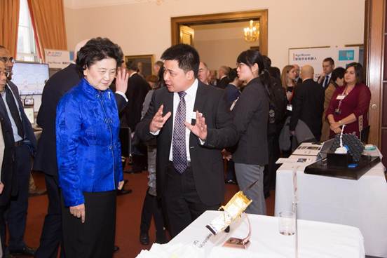
Professor Li Zhenhong (right) is introducing the achievements of Gaofen-3 satellite to Vice Premier of the State Council Liu Yandong (left)
Also present at the exhibition were Wang Zhigang, Secretary of the CPC Leading Group and Vice Minister, Ministry of Science and Technology (MOST), Prince Andrew, Duke of York and Jo Johnson, the UK's minister of state for universities, science, research and innovation, etc.
Co-sponsored by MOST of the People`s Republic of China and Department for Business, Energy and Industrial Strategy (BEIS) of the United Kingdom, the forum was held in the Royal Society, which is one of the important activities of the Fifth Meeting of China-UK High-level People-to-People Dialogue. The forum attracted almost 300 participants from the both sides, such as senior officials from different ministries, presidents, academicians, Nobel winners and senior entrepreneurs, etc. The Memorandum of Understanding documents for the China-UK Joint Strategy for Science, Technology and Innovation Cooperation was officially signed. This strategy will support the exploration of new opportunities through the partnership between scientific research and industrial domain in both countries to tackle global challenges together.
There are 26 projects on display in this exhibition. Two projects are from the team of Li Zhenhong, the external expert of Collaborative Innovation Center of Geospatial Technology and professor of Newcastle University. One of the two projects is Repeat-Pass Radar Interferometry of Gaofen-3 satellite and its application achievements. This achievement is co-competed by Li Zhenhong’s British research team and the team of Zhang Qingqun, chief scientist on Aerospace Information Acquisition of Collaborative Innovation Center for Geospatial Technology and mission manager of China Academy of Space Technology(CAST).
Liu Yandong watched the 3D mock-up of the Gaofen-3 satellite and asked about the GF-3 application scenarios and future development. Li Zhenhong introduced that the GF-3 satellite can be used to extract the surface displacement information of centimeter or even sub-centimeter level. This achievement can be applied to the prevention and reduction of geology disasters, including earthquakes, landslides, urban land subsidence and earth's surface sinking caused by coal mining. The team is working with domestic experts to develop an early warning system for landslides, in order to avoid, as far as possible, the recurrence of similar landslide tragedy like what happened in Maoxian , June 2017. Liu Yandong spoke highly of this.
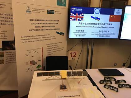
The 3D mock-up stand of the Gaofen-3 satellite
It is reported that, on 10th August, 2016, Gaofen-3 satellite was successfully launched from the Taiyuan Satellite Launch Center, which was put into operation at the end of January 2017. This is the first high-resolution satellite in China, configured with multi-polarized C-band Synthetic Aperture Radar (SAR), which aims at providing remote sensing data with high resolution and multiple imaging modes so as to achieve an all-weather and around-clock information monitoring on global ocean and land. Gaofen-3’s SAR package can operate in 12 different working modes, which can capture satellite images with a resolution between 1 to 500 meters and the corresponding viewing swath ranging from 10 to 650 kilometers. Moreover, it features reconnaissance capabilities and is capable of taking wide pictures of earth and photographing detailed scenarios of specific areas. Furthermore, with a high level of satellite quantization, the image quality index has reached or exceeded that of similar SAR satellites both home and abroad. Since its entry into orbit, GF-3 has obtained nearly 100,000 multi-polarized C-band ocean and land SAR images, which plays an important role in data supporting for many application departments, such as domestic and foreign resources survey, storm alert, hazard assessment, agricultural production assessment, polar research, etc.
(Rewritten by Ge Chao, edited by Shen Yuxi, Hu Sijia)