On Oct 1, a grand gathering, military parade and mass pageantry were held to celebrate the 70th founding anniversary of the People's Republic of China on the Tian'anmen Square. The Mobile Mapping System (MMS) for military uses, co-developed by WHU and Leador Spatial Information Technology Corporation, were demonstrated on the formation of strategic support force.
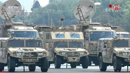
At about 11:00 a.m., the fourth formation of information operations passed Tian'anmen Square in front of all the people for inspection. This formation consists of more than seventy front-line officers and soldiers from the strategic support force, who were all experts in surveying and mapping. This formation is an excellent warrior in the information battlefield with golden eyes into the heaven and the earth. This parade is the debut of such China-developed equipment as the meteorological and hydrological observation vehicles, topographic survey vehicles, forecast support vehicles, navigation vehicles for surveying and mapping information service.
A line of off-road vehicles for military uses, equipped with mysterious sensors, stood out in their huge, sci-fi figures. They were the outstanding equipment for surveying and mapping—MMS, co-developed by Academician Li Deren from the State Key Laboratory of Information Engineering in Surveying, Mapping and Remote Sensing (Wuhan University) and the Laboratory and Leador Spatial Information Technology Corporation.
MMS is a kind of vehicle-mounted measuring equipment, which can quickly collect three-dimensional geographic information with high precision that can work together with data collected from the UAV (Unmanned Aerial Vehicle), planes and remote sensing satellite to form an integrated geospatial information system.
As we say, “Surveying and mapping operates before troops.” It is of equal importance with geographic information technology in modern wars. The international blockades in early times on such technologies as inertial navigation urge the Lab and the corporation to self-independently come up with a set of innovative concepts, theories, techniques and products. Under the leadership of Academician Li Deren, the team finally overcame the key technical difficulties after an over-a-decade arduous journey and started a new era in China. Moreover, the advanced technology has been successfully applied to national defense so as to noticeably enhance the guarantee capacity of Chinese army.
Rewritten by Chen Muying, edited by Zhang Shiqi, Shen Yuxi and Hu Sijia