It almost takes no time to find your favorite stores in the shopping mall; your attention to a painting for more than 5 seconds in the exhibition hall will be sensed by smart phones which will then give you a detailed introduction; an elephant memory is no longer required when looking for your car in the underground garage, nor do you need to take detours ... These living facilities will soon become reality in shopping malls and buildings in Wuhan Jianghan District.
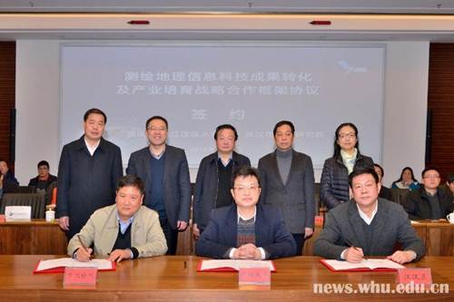
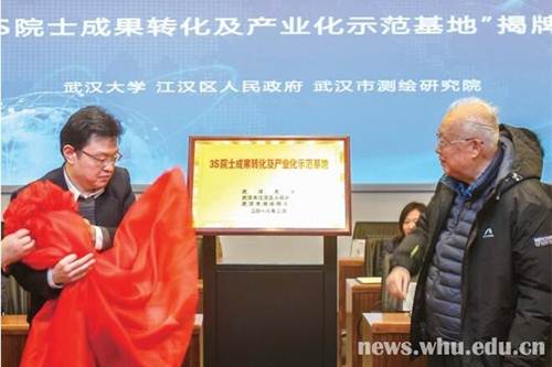
In February 6, Wuhan University, Jianghan District Government and Wuhan Institute of Surveying and Mapping signed the strategic cooperation framework of "World's First Seamless Navigation Demonstration Zone" to jointly promote the 13th Five-Year major R & D program —— "High Availability and High Precision Indoor Intelligent Hybrid Positioning and Indoor GIS Technology". At the same time, "3S Academician Achievements Transformation and Industrialization Demonstration Base" was inaugurated.
It means that the indoor precision positioning and navigation technology will be fully piloted in Jianghan District. New industrial chains, industrial clusters, talent clusters and demonstration areas of achievement transformation and application will be fostered, driven by the information industry.
Wuhan University, Jianghan District and Wuhan Institute of Surveying and Mapping, based on their own resources with a clear allocation of tasks, contributed to the development of the "whole industry chain" of mapping and geographic high technologies. Wuhan University is responsible for providing talents and cutting-edge technical supports in such areas as intellectual input, technology transfer, teamwork and transformation of scientific and technological achievements. The government of Jianghan District provided policy guidance and efficient administrative approval services to obtain policy and financial supports. Wuhan City Institute of Surveying and Mapping is in charge of providing basic data services and technical personnel support for the implementation of the project.
"Wuhan University's surveying and mapping remote sensing discipline is a glowing flag of Wuhan city and is expected to contribute to its urban development. Together with the two other parties, we carried out the R & D practice of this project so that the new technology will actually take off and contribute to the construction and management of Wuhan." Vice President Li Jiancheng, also an academician of the Chinese Academy of Engineering, explained that Wuhan University is of world-class level in surveying and mapping. “We are facing the best period of opportunities to transform our achievements.” He said.
Zhang Junyong, secretary of Jianghan District CPC Committee, introduced that the Seamless Pilot Demonstration Zone will rely on the industrialization base of academician projects to nurture the industrial chain of indoor navigation and positioning and get it integrated into the entity economy so as to promote the improvement the quality and productivity of the modern service industry in the region.
The construction of Seamless Navigation Demonstration Area involves collecting and producing indoor map data, deploying indoor positioning equipment and mobile phone clients, etc. Based on the platform of high precision indoor and outdoor positioning and navigation technology, seamless navigation services will be provided in large indoor public places in Jianghan District, according to Chen Ruizhi, director of the State Key Laboratory of Surveying, Mapping and Remote Sensing Information, said that the content of
Xiao Jianhua, president of Wuhan Institute of Surveying and Mapping, suggested that he would work with Wuhan University to give full play to their respective advantages, transform the latest research results of "3S technology" of the academicians and experts into industrial projects to fuel the urban economy.
“With the rapid advancement of modern science and technology, mapping and geographic information technology also needs transformation and upgrading. The construction of the world’s first Seamless Navigation Demonstration Area is a pioneering scientific and technological innovation practice, which is important not only for Jianghan District and Wuhan City, but also for the nation and the whole world.” Ning Jinsheng, an academician of the Chinese Academy of Engineering, spoke highly of the significance of seamless navigation and expressed his expectations for the construction of the demonstration area.
It is reported that the Seamless Navigation Demonstration Area will first be piloted in large commercial plazas and financial buildings, and then be extended to large conference and exhibition centers, logistics warehouses, railway stations, museums, hospitals and other public places. Indoor positioning navigation technology will play a role in government functions management, urban construction, resource development, environmental protection and people's livelihood services.
(Photo by Wuhan Institute of Surveying and Mapping)
(Rewritten by Jing Huichao, Edited by Zheng Lingling, Shen Yuxi, Hu Sijia)