A team from Wuhan University's School of Resources and Environmental Sciences and School of Urban Design has made significant advances in the study of the wildland-human interface (WHI) on a global scale.
Their research, The rising threats of global wildland-human interface revealed by a scale-adaptive approach, has been published online in Proceedings of the National Academy of Sciences (PNAS).
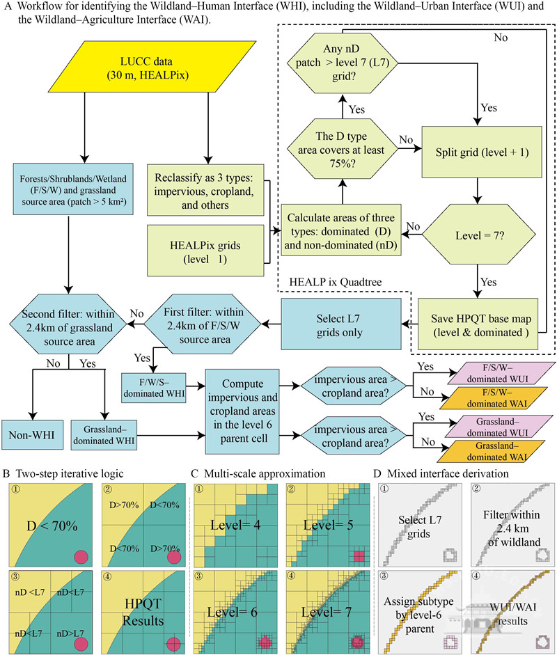
The study provides a consistent global definition of the WHI for the first time, distinguishing between the "wildland-agriculture interface" (WAI) and the "wildland-urban interface" (WUI).
The team has also developed a high-resolution dynamic map of the WHI from 2000 to 2020, offering new scientific insights for assessing risks to socio-ecological systems, biodiversity conservation, and sustainable land-use decision-making.
As agricultural expansion and urban sprawl increase, human activities are more encroaching on natural wildlands, creating critical zones where nature and humanity intersect.
These areas are hotspots for risks such as wildfires, habitat fragmentation, and biodiversity loss. However, there has been a lack of globally consistent and comparable methods to define these interfaces, particularly in understanding their different types and dynamic evolution.
To address this knowledge gap, the team introduced an innovative scale-adaptive HEALpix Quadtree (HPQT) algorithm, overcoming the scale bias and projection distortion issues associated with traditional fixed-grid methods, enabling globally comparable and regionally adaptive spatial calculations of the WHI (including WAI and WUI).
The study reveals that, from 2000 to 2020, the global WUI area increased by 59.76 percent, primarily driven by urban sprawl. Although the overall WAI area slightly decreased, it experienced significant spatial shifts, reflecting the rapid expansion of agricultural land into natural areas.
The WAI accounted for over 97 percent of interface wildfires, with fire radiative intensity showing a "first increase, then decrease" spatial pattern, highlighting the potential for agricultural activities to induce wildfires and the distance decay effect.
 中文
中文