A team led by Professor Feng Lian from the State Key Laboratory of Information Engineering in Surveying, Mapping and Remote Sensing at Wuhan University has made significant progress in understanding the evolution of surface water connectivity in global river-floodplain systems.
Their study, Global net increase in surface water connectivity in river–floodplain systems, has been published in Nature Geoscience, utilizing nearly 40 years of optical satellite remote sensing data at a 30-meter resolution to develop a model for assessing surface water connectivity in river-floodplain systems.
The team quantified the surface water connectivity of nearly 30,000 river segments worldwide, creating the first global dataset at the river segment scale and revealing significant seasonal differences in connectivity patterns within river-floodplain systems.
Under typical flooding conditions, about 40 percent of global river segments remain connected to more than half of the nearby floodplain water bodies. High-connectivity segments are found in the Mackenzie, Yukon, and Amazon rivers, while low-connectivity segments are located in the Ganges-Brahmaputra-Meghna, Niger, and Indus rivers.
The study traced changes in global surface water connectivity over nearly 40 years, divided into three periods (1984-1999, 2000-2009, 2010-2019). From the 1990s to the 2010s, global connectivity exhibited a net increase (+3 percent), with the number of segments showing continuous increase (17 percent), about 1.5 times that of those showing continuous decrease (11 percent).
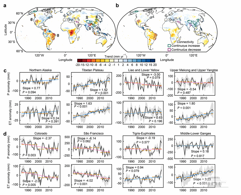
Regions with sustained connectivity enhancement are concentrated in East Asia and the circum-Arctic, while arid and semi-arid regions, including eastern South America, central North America, and southern Asia, show a continuous decline.
The study also found that about 30 percent of global river segments experienced connectivity transitions, with increases followed by decreases, or vice versa, across the three periods.
For instance, connectivity in Europe, northwestern India, and southeastern Australia increased over the past 20 years following a decline in the 1990s, in contrast to significant declines in connectivity in rivers such as the Negro in southern South America and the Stanovoy Range in Siberia.
The study highlights that climate factors, such as rainfall and evapotranspiration, are primary drivers of changes in connectivity. However, in certain hotspot areas where climate change impacts are decoupled, such as the upper Mekong, Liao, and lower Yellow rivers, human activities such as dam construction, afforestation, and irrigation play a regulatory role at local scales.
There is a significant correlation between changes in suspended sediment concentration and surface water connectivity, with about 60 percent of basins exhibiting positive correlations.
 中文
中文